2015 US Club, 18-Meter and Open Class Nationals
June 23rd to July 2nd, 2013 (Practice Days June 21st and 22nd)
Hobbs Industrial Airpark (NM83), Hobbs, NM
![]()
![]()
![]()
![]()
![]()
![]()
![]()
![]()
|
|
2015 US Club, 18-Meter and Open Class Nationals |
|
|
Adapted from Charlie Spratt
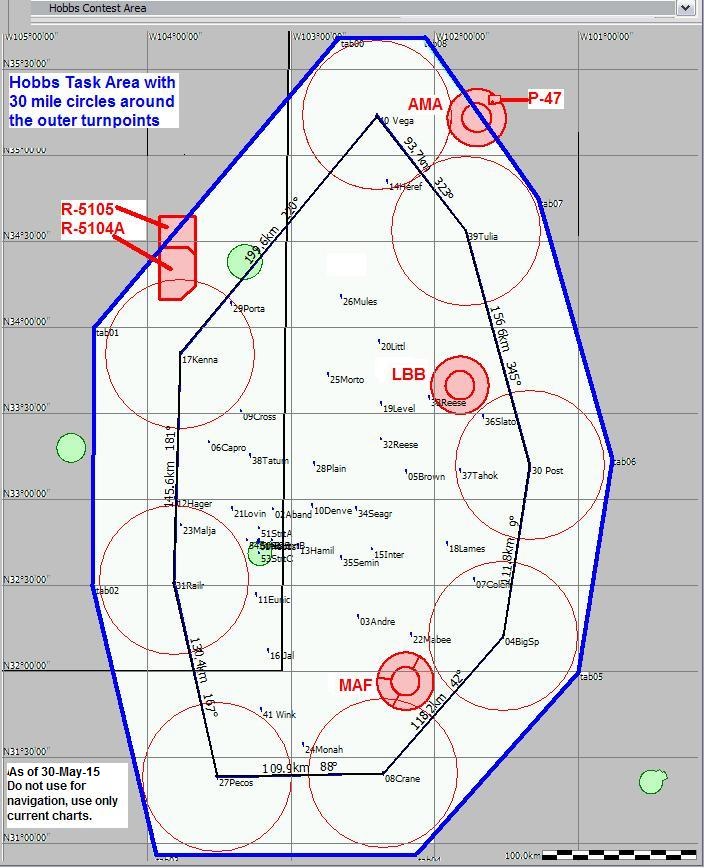
With the city of Lubbock Texas some 60 miles from the New Mexico border the turnpoint area for Hobbs is in both states. For the most part all the turnpoints are up on the “Caprock.” This is a geological area formed by an ancient sea. The Caprock is defined by sharp escarpments on the west and east boundaries Going west the terrain slowly changes from flat farm and ranch land to desert scrub. As you get closer to the western edge the land becomes more desert like and is known to Soaring Pilots by its nickname “The Rocks.” The northern part of the task area is all farmland with the major crop being “Dry Land Cotton.” This area is such a safe land-out area that the US Air Force uses it each spring to train new glider pilots in cross-country flying. To the south is the largest oil field in the United States. It is dotted with huge cattle ranches and many ranch and crop duster airports. To the west the pilots are quickly off the Caprock and into the mixed grass rolling plains of West Texas.
CLOSED AIRSPACE
The competition area (outlined in blue in the diagram below) historically contains 6 areas of airspace that are always closed for the purposes of the competition (shown in red).
To the NW lie two adjacent restricted areas,
To the SE is the Midland-Odessa (MAF) Class C area
To the near NE is the Lubbock (LBB) Class C area
To the far NE is the Amarillo (AMA) Class C area and the P-47 Prohibited area
Note that although (as of 2010 competition rules) you may fly under closed airspace, you may not fly over it. Details of the airspace should be reviewed on current sectional charts.
Please read the Hobbs Contest Briefing and the Hobbs Airfield Notes
Worldwide Soaring Turnpoint Exchange
Maps Required:
Sectionals: Albuquerque; Dallas Fort Worth; El Paso; San Antonio